Itinerary
You should plan to arrive into Oslo, Gardermoen Airport by midday on this day. On arrival you will need to head to the airport train station and take the afternoon train to Otta, where you will be met by your Tour Leader. From Otta we transfer by minibus to Gjendesheim (995m) on the eastern edge of the Jotunheimen Mountains. We stay overnight at the Gjendesheim Hut.
Accommodation
Mountain Hut / Refuge
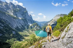
Today, we hike the Besseggen route, arguably Norway's most famous mountain walk, which follows a narrow ridge between the lakes of Bessvatn to the north and Gjende to the south. We can arrange to send our main luggage to Memurubu by boat to make the day's walk more enjoyable. During today's hike we will need to carry our waterproof clothing and a packed lunch. After breakfast at the hut, we start out in a northerly direction, climbing steeply on the path which leads to Glitterheim. After half an hour, however, we turn off towards Besseggen and begin a long climb to the broad, open top of Veslfjellet (1743m). Descending now, the ridge narrows and we walk alongside the blue water of Bessvatn to our right, whilst the green water (rich in glacial sediment) of Gjende lie some 400 metres below us to our left. The descent of Besseggen Ridge is a continuous scramble and will take about 40 minutes but the scrambe is relatively easy, on big steps. The ridge is reasonably wide so you are rarely near to the edge, which means that it should not feel overly exposed and is achievable for most confident walkers. The views as you descend from the ridge are spectacular and remain so for the whole day, as you are looking around from a lofty vantage point. We pass a small lake on a high plateau and then descend to our overnight stop at the lodge at Memurubu (1008m).
Accommodation
Mountain Hut / Refuge
This trek through the beautiful and remote valley of Utladalen is perhaps one of the longest days of the trip, we will be covering a long distance and whilst carrying all our luggage. In the morning we have a short 20mins boat ride along the beautiful Gjende Lake to Gjendebu. We then trek to Spiterstulen via the Utladalen Valley. We start at approx 1000m and walk along the Storadalen valley by the side of the river up a small tarn and then the Langvatnet Lake at around 1400m. We then fork off northwards up to the pass at Urdadalsbandet at 1663m between the peaks and glaciers of Visbretinden, Semelholstinden, Hellstugutinden and Memurubrean. We have spectacular views from here to the Svellnosbrean and Galhopiggen area, which we explore over the next few days. From the pass, we descend to the Visdalen valley for some level walking to the Spiterstulen Hut.
*NOTE* if you would prefer to save your legs, it is possible to travel by bus from Gjendesheim to Lom, and then from Lom to Spiterstulen. Lom has a stave church, a museum and a great bakery. If you would prefer to take this option then your Tour Leader will be able to advise on bus timings. You will need to pay for the bus ticket directly and this cannot be booked in advance.
Accommodation
Mountain Hut / Refuge
We will be spending 3 nights at the Spiterstulen Hut, which means that we can leave some items of our gear behind today, as we go off to climb Galdhopiggen (2469m) the highest peak in Norway. This peak rises up on the west side of the valley and after crossing a bridge across the Visa River, we initially ascend on a good, way-marked trail but the path becomes increasingly rocky under foot as we make our way up this giant, boulder-strewn mountain. Though we are never required to walk too near to the edge, some vertiginous drops make for breath-taking views. Up to about 1800 metres the trail is steep and then levels off as we come within sight of the subsidiary peak of Svellnosi. As we gain height, the views, especially to the south and south-west, become increasingly impressive. We pass the rocky tops of Svellnosi and then Keilhaus Topp (2355m) with large snow patches to cross in between. We have good views of the impressive Svellnos Glacier to the left and the Stygge Glacier to the right. At the summit, there is a stone-built hut where hot drinks and chocolate bars can be purchased. We return by the same route to our accommodation at Spiterstulen.
Accommodation
Mountain Hut / Refuge
At the hut, our guide will issue us with harness, helmet, ice-axe (if required) and crampons and will make sure that everything is fitted correctly before we strap the items to our rucksacks. From the hut we have an easy walk southeast from the hut to the Svellnosbreen Glacier, which shouldn’t take more than 3 hours. After crossing the multiple streams in the valley on make-shift bridges, we follow a ridge of glacial moraine up to the base of the glacier, where we don our equipment and rope up. Here we trek through the blue ice with tall ice formations and deep crevasses. We rope up and explore this glacier on an upwards journey, following natural path-ways and depressions in the ice and taking big steps over the occasional chasm. We are likely to use our ice axe and crampons pull ourselves up short sections of slope but this is achievable for total novices and the guide is always on hand to assist. This is a fantastic day out but anyone feeling in need of a rest-day at the hut can certainly opt to do so.
Accommodation
Mountain Hut / Refuge
After 2 long mountain days, today's easy hike through the spectacular valley of Visdalen will make a pleasant change. We climb very gradually to a high point at 1500m and enjoy great views of peaks and glaciers en route to our overnight stop at the lakeside mountain refuge at Leirvassbu (1400m). We are unlikely to see many other trekkers during the second part of our week, as the western ranges have a more remote aspect. The days are long in this part of the world in summer and after lunch at the lodge, those who are still feeling fresh will have the option to climb the striking peak of Kyrkja (the Church) (2032m), which rises up above Leirvassbu.
The ascent of Kyrkja involves about 20 minutes of scrambling to the top and, though of a similar level of difficulty to Besseggen, it has a steeper feel. If this option is taken you will need to add 5.5km, 600m and 3 hours to the statistics for distance, ascent and trekking time listed below.
Accommodation
Mountain Hut / Refuge
Today's walk is generally downhill all the way to Skogadalsboen, a very pleasant hut which is situated amongst the Jotunheimen's wildest peaks. The walk starts out beside a string of lakes and follows the refuge access road, before turning off on a marked trail through the Gravdalen Valley. Underfoot conditions will include dirt road, rocky trail and extensive snow patches.The surrounding peaks and valleys become increasingly green as we head towards the coast.The last part of today's walk is through pretty birch woodland.
Accommodation
Mountain Hut / Refuge
Our final, beautiful day's trek takes us southwards from the hut, climbing to a high point at around 1200m below Mount Friken (1503m). On this first part of the walk, there are superb views of some of Norway's most spectacular peaks, including those of the Hurrungane Mountains. We then begin a gradual descent into the stunning valley of Utladalen, passing mountain farms and summer cabins, and we get to see Vettisfossen, Norway's highest waterfall, with a vertical drop of 275m. On reaching the valley floor, save some energy for the 30 min climb up to the Avdalen refuge, above the Avdal waterfall.
Accommodation
Mountain Hut / Refuge
We have an early breakfast at the refuge and then make the 1-hour walk (200m descent) out to the road, where we meet the bus which will take us back to the bus depo in Oslo. From the bus depot in Oslo, you will need to take the express shuttle train out to Gardermoen Airport. The train operates every 10 minutes and the journey takes 20 minutes. You should arrive at Oslo Gardermoen Airport in the mid afternoon.
Download Trip Notes
The Route
Use two fingers to move the map
Array
(
[0] => Array
(
[id] => 01hgdb7t0hccaja6tjm48znk0w
[name] => NOR Traverse of the Jotunheimen of Norway
[code] => NOR
[ordering] => 1
[introduction] =>
[description] => 8 nights mountain huts, 8 days trekking, Max altitude - 2472m, Join in Otta, MEAL PLAN: All meals included
[map] =>
[fields] => Array
(
[0] => Array
(
[__typename] => BoolFieldData
[name] => all_meals_included
[bool] => 1
)
[1] => Array
(
[__typename] => NumberFieldData
[name] => group_size_maximum
[number] => 15
)
[2] => Array
(
[__typename] => NumberFieldData
[name] => group_size_minimum
[number] => 4
)
[3] => Array
(
[__typename] => StringFieldData
[name] => joining_point
[string] => Otta
)
[4] => Array
(
[__typename] => StringFieldData
[name] => map_json
[string] => {"type":"FeatureCollection","zoom":9,"center":[61.4925595587251,8.39080810546875],"features":[{"type":"Feature","geometry":{"type":"Point","coordinates":[8.809576034545898,61.49548839406595]},"properties":{"type":"Marker","icon":{"iconType":"point","iconUrl":"//www.keadventure.com/libraries/mrzen/assets/images/map-icons/point.png"}}},{"type":"Feature","geometry":{"type":"Point","coordinates":[8.81378173828125,61.44796417310333]},"properties":{"type":"Label","text":"Gjendesheim"}},{"type":"Feature","geometry":{"type":"Point","coordinates":[8.631134033203125,61.49206797892427]},"properties":{"type":"Marker","icon":{"iconType":"point","iconUrl":"//www.keadventure.com/libraries/mrzen/assets/images/map-icons/point.png"}}},{"type":"Feature","geometry":{"type":"Point","coordinates":[8.536376953125,61.438775802524766]},"properties":{"type":"Label","text":"Memurubu"}},{"type":"Feature","geometry":{"type":"LineString","coordinates":[[8.809318542480469,61.49583655895436],[8.807601928710938,61.50025996185378],[8.807601928710938,61.5014066673534],[8.803138732910156,61.50664821136602],[8.795928955078125,61.50730334226268],[8.786659240722656,61.50795845935892],[8.771553039550781,61.50697577853939],[8.76708984375,61.50484653024019],[8.759536743164062,61.50435514454652],[8.752326965332031,61.50501032374625],[8.746490478515625,61.505174116389746],[8.7396240234375,61.50501032374625],[8.732414245605469,61.50451894064031],[8.726921081542969,61.503699951545485],[8.718338012695312,61.50288094088576],[8.713874816894531,61.5025533305836],[8.708038330078125,61.5025533305836],[8.701171875,61.50271713616598],[8.694305419921875,61.5033723498694],[8.682975769042969,61.50386375108964],[8.678855895996094,61.5033723498694],[8.674392700195312,61.50206190866071],[8.668556213378906,61.50157047897417],[8.663749694824219,61.50107904152388],[8.658599853515625,61.5004237795131],[8.652763366699219,61.498457910664555],[8.644523620605469,61.496164239996375],[8.636970520019531,61.49485349512226],[8.630447387695312,61.491904117265]]},"properties":{"type":"Polyline","weight":"2","color":"#E21C24","lineType":"trek"}},{"type":"Feature","geometry":{"type":"Point","coordinates":[8.408660888671875,61.63315925979687]},"properties":{"type":"Marker","icon":{"iconType":"point","iconUrl":"//www.keadventure.com/libraries/mrzen/assets/images/map-icons/point.png"}}},{"type":"Feature","geometry":{"type":"Point","coordinates":[8.448486328125,61.61944357365509]},"properties":{"type":"Label","text":"Spiterstulen"}},{"type":"Feature","geometry":{"type":"LineString","coordinates":[[8.406600952148438,61.63348549368684],[8.396987915039062,61.63315925979687],[8.389434814453125,61.63185428983452],[8.37982177734375,61.63185428983452],[8.366775512695312,61.63413795114623],[8.359909057617188,61.63609524096179],[8.3441162109375,61.639683283988596],[8.32763671875,61.64000944907953],[8.310470581054688,61.63609524096179]]},"properties":{"type":"Polyline","weight":"2","color":"#E21C24","lineType":"trek"}},{"type":"Feature","geometry":{"type":"Point","coordinates":[8.31390380859375,61.64522762275568]},"properties":{"type":"Marker","icon":{"iconType":"peak_large","iconUrl":"//www.keadventure.com/libraries/mrzen/assets/images/map-icons/peak_large.png"}}},{"type":"Feature","geometry":{"type":"Point","coordinates":[8.245925903320312,61.55018437002813]},"properties":{"type":"Marker","icon":{"iconType":"point","iconUrl":"//www.keadventure.com/libraries/mrzen/assets/images/map-icons/point.png"}}},{"type":"Feature","geometry":{"type":"LineString","coordinates":[[8.2452392578125,61.55083858364419],[8.256912231445312,61.553455300242895],[8.26446533203125,61.553455300242895],[8.27545166015625,61.552146969516244],[8.3001708984375,61.552146969516244],[8.322830200195312,61.55018437002813],[8.349609375,61.56097713183733],[8.378448486328125,61.56947787688092],[8.391494750976562,61.5812442944686],[8.39630126953125,61.59594603934757],[8.3990478515625,61.60868191161278]]},"properties":{"type":"Polyline","weight":"2","color":"#E21C24","lineType":"trek"}},{"type":"Feature","geometry":{"type":"Point","coordinates":[7.9815673828125,61.54625824609185]},"properties":{"type":"Label","text":"Leirvassbu"}},{"type":"Feature","geometry":{"type":"Point","coordinates":[8.00628662109375,61.4597705702975]},"properties":{"type":"Marker","icon":{"iconType":"point","iconUrl":"//www.keadventure.com/libraries/mrzen/assets/images/map-icons/point.png"}}},{"type":"Feature","geometry":{"type":"LineString","coordinates":[[8.00628662109375,61.460098631103065],[8.00628662109375,61.46633113021747],[8.004913330078125,61.47354615071025],[8.015213012695312,61.48567673482926],[8.041305541992188,61.489609963437104],[8.074264526367188,61.49321498638018],[8.114089965820312,61.505337908170645],[8.142242431640625,61.5131988993387],[8.167648315429688,61.51352639751439],[8.195114135742188,61.52040306238226],[8.200607299804688,61.52695085289318],[8.2232666015625,61.53316997618226],[8.2452392578125,61.53709720216927],[8.249359130859375,61.54495016475123],[8.247299194335938,61.54887590143483]]},"properties":{"type":"Polyline","weight":"2","color":"#E21C24","lineType":"trek"}},{"type":"Feature","geometry":{"type":"Point","coordinates":[8.065338134765625,61.44107059453409]},"properties":{"type":"Label","text":"Skogadalsboen"}},{"type":"Feature","geometry":{"type":"Point","coordinates":[7.92388916015625,61.37468645751083]},"properties":{"type":"Marker","icon":{"iconType":"point","iconUrl":"//www.keadventure.com/libraries/mrzen/assets/images/map-icons/point.png"}}},{"type":"Feature","geometry":{"type":"Point","coordinates":[7.95684814453125,61.34671330807378]},"properties":{"type":"Label","text":"Vetti"}},{"type":"Feature","geometry":{"type":"LineString","coordinates":[[7.925262451171875,61.37534436644899],[7.9355621337890625,61.380936033590665],[7.9541015625,61.390143658580335],[7.9698944091796875,61.40066333772906],[7.9795074462890625,61.40986515187973],[7.98431396484375,61.41775026352099],[7.991180419921875,61.42530496028017],[7.9891204833984375,61.429902576096275],[7.9877471923828125,61.43252948098861],[7.991180419921875,61.44008060055631],[8.004913330078125,61.450911622920444],[8.005599975585938,61.45845829253681]]},"properties":{"type":"Polyline","weight":"2","color":"#E21C24","lineType":"trek"}},{"type":"Feature","geometry":{"type":"Point","coordinates":[8.11065673828125,61.65467687072117]},"properties":{"type":"Label","text":"Galdhopiggen"}},{"type":"Feature","geometry":{"type":"Point","coordinates":[8.096923828125,61.526623496130696]},"properties":{"type":"Marker","icon":{"iconType":"arrow_w_sw","iconUrl":"//www.keadventure.com/libraries/mrzen/assets/images/map-icons/arrow_w_sw.png"}}},{"type":"Feature","geometry":{"type":"Point","coordinates":[8.41552734375,61.558688071727936]},"properties":{"type":"Marker","icon":{"iconType":"arrow_n_nw","iconUrl":"//www.keadventure.com/libraries/mrzen/assets/images/map-icons/arrow_n_nw.png"}}},{"type":"Feature","geometry":{"type":"Point","coordinates":[8.72589111328125,61.50697577853939]},"properties":{"type":"Marker","icon":{"iconType":"peak_medium","iconUrl":"//www.keadventure.com/libraries/mrzen/assets/images/map-icons/peak_medium.png"}}},{"type":"Feature","geometry":{"type":"Point","coordinates":[8.65997314453125,61.51876258203925]},"properties":{"type":"Label","text":"Besseggen Ridge"}},{"type":"Feature","geometry":{"type":"Point","coordinates":[8.307723999023438,61.61945432958135]},"properties":{"type":"Marker","icon":{"iconType":"point","iconUrl":"//www.keadventure.com/libraries/mrzen/assets/images/map-icons/point.png"}}},{"type":"Feature","geometry":{"type":"LineString","coordinates":[[8.403167724609375,61.632180537485524],[8.396987915039062,61.62957045994692],[8.389434814453125,61.624349644279874],[8.37432861328125,61.61847517372931],[8.366775512695312,61.617822385954454],[8.354415893554688,61.617822385954454],[8.347549438476562,61.617822385954454],[8.334503173828125,61.61716958441388],[8.325576782226562,61.61716958441388],[8.318023681640625,61.61716958441388],[8.30841064453125,61.61847517372931]]},"properties":{"type":"Polyline","weight":"2","color":"#E21C24","lineType":"trek"}},{"type":"Feature","geometry":{"type":"Point","coordinates":[8.00628662109375,61.595946039347574]},"properties":{"type":"Label","text":"Svellnobrean"}},{"type":"Feature","geometry":{"type":"LineString","coordinates":[[8.482818603515625,61.45058346539831],[8.477325439453125,61.45058346539831],[8.469085693359375,61.45025530442164],[8.446426391601562,61.454849243741634],[8.440933227539062,61.4581302144619],[8.438186645507812,61.46108279279709],[8.430633544921875,61.46731509506142],[8.428573608398438,61.47157858359168],[8.42376708984375,61.47715303426695],[8.416213989257812,61.489609963437104],[8.410720825195312,61.491904117265],[8.395614624023438,61.495508874461365],[8.386001586914062,61.50009614333176],[8.383941650390625,61.50795845935892],[8.388748168945312,61.51909333873095],[8.403854370117188,61.526623496130696],[8.404541015625,61.53447910667831],[8.40728759765625,61.54167833832986],[8.405227661132812,61.54887590143483],[8.399734497070312,61.559342106132064],[8.398361206054688,61.56653557487185],[8.3990478515625,61.57470794697425],[8.400421142578125,61.587452548470026],[8.40179443359375,61.59594603934757],[8.40179443359375,61.60443720265596],[8.40179443359375,61.61129375105759],[8.402481079101562,61.618801562454685],[8.407974243164062,61.626307553376805],[8.407974243164062,61.63152803874317]]},"properties":{"type":"Polyline","weight":"2","color":"#E21C24","lineType":"trek"}},{"type":"Feature","geometry":{"type":"LineString","coordinates":[[8.630447387695312,61.48862670288195],[8.630447387695312,61.48567673482926],[8.6297607421875,61.48305430628325],[8.62152099609375,61.48075950007598],[8.616714477539062,61.4801038100904],[8.602294921875,61.476497268329794],[8.592681884765625,61.47485779306746],[8.58306884765625,61.47092270026257],[8.57208251953125,61.468299028826316],[8.556289672851562,61.465675136388356],[8.549423217773438,61.46436310728962],[8.545303344726562,61.46337904920435],[8.534317016601562,61.461410839787646],[8.529510498046875,61.460426688454824],[8.524017333984375,61.4581302144619],[8.515090942382812,61.456489772277685],[8.504104614257812,61.4515679276012],[8.498611450195312,61.45058346539831],[8.490371704101562,61.45058346539831],[8.486251831054688,61.4515679276012]]},"properties":{"type":"Polyline","weight":"2","color":"#00FF00","lineType":"transfer"}}]}
)
[5] => Array
(
[__typename] => StringFieldData
[name] => tour_summary
[string] => 8 days trekking, Max altitude - 2472m
)
[6] => Array
(
[__typename] => NumberFieldData
[name] => tz3_id
[number] => 237
)
)
[locations] => Array
(
[0] => Array
(
[name] => Norway
[category] => Array
(
[name] => Country
)
)
)
[elements] => Array
(
[0] => Array
(
[id] => 01hgdb7tp4cwjgma4vqszx0mzr
[name] => Tour Space
[is_package] => 1
[options] => Array
(
[0] => Array
(
[id] => 01hgdb7trjvta0ajyb3p2zwk6y
[name] => Adult Flight Inclusive Price
[leadPrice] =>
)
[1] => Array
(
[id] => 01hgdb7v0md1eq7p0na6cyckqr
[name] => Adult Price
[leadPrice] => Array
(
[value] => 2685
[previous_value] => 2550
[currency] => USD
)
)
)
)
)
[itinerary] => Array
(
[0] => Array
(
[id] => 01hgdb7t89m0h0d83mhtzedp9m
[title] => Trek the Besseggen Ridge Route, via Veslfjellet (1743m) to Memurubu (1008m).
[introduction] =>
[description] => Today, we hike the Besseggen route, arguably Norway's most famous mountain walk, which follows a narrow ridge between the lakes of Bessvatn to the north and Gjende to the south. We can arrange to send our main luggage to Memurubu by boat to make the day's walk more enjoyable. During today's hike we will need to carry our waterproof clothing and a packed lunch. After breakfast at the hut, we start out in a northerly direction, climbing steeply on the path which leads to Glitterheim. After half an hour, however, we turn off towards Besseggen and begin a long climb to the broad, open top of Veslfjellet (1743m). Descending now, the ridge narrows and we walk alongside the blue water of Bessvatn to our right, whilst the green water (rich in glacial sediment) of Gjende lie some 400 metres below us to our left. The descent of Besseggen Ridge is a continuous scramble and will take about 40 minutes but the scrambe is relatively easy, on big steps. The ridge is reasonably wide so you are rarely near to the edge, which means that it should not feel overly exposed and is achievable for most confident walkers. The views as you descend from the ridge are spectacular and remain so for the whole day, as you are looking around from a lofty vantage point. We pass a small lake on a high plateau and then descend to our overnight stop at the lodge at Memurubu (1008m).
[S] => 2
[E] => 2
[B] => 1
[L] => 1
[D] => 1
[fields] => Array
(
[0] => Array
(
[__typename] => StringFieldData
[name] => accommodation_style
[string] => Mountain Hut / Refuge
)
[1] => Array
(
[__typename] => StringFieldData
[name] => gis_data_link
[string] =>
)
[2] => Array
(
[__typename] => NumberFieldData
[name] => trek_ascent
[number] => 1120
)
[3] => Array
(
[__typename] => NumberFieldData
[name] => trek_descent
[number] => 1080
)
[4] => Array
(
[__typename] => NumberFieldData
[name] => trek_distance
[number] => 15
)
[5] => Array
(
[__typename] => StringFieldData
[name] => trek_time
[string] => 7 - 8 hrs trekking
)
[6] => Array
(
[__typename] => NumberFieldData
[name] => tz3_id
[number] => 2604
)
)
)
[1] => Array
(
[id] => 01hgdb7tjs5ptt1w0p7z0pvb92
[title] => Trek through the Utadalen Valley to Avdalen. Optional walk above the Avdal Waterfall.
[introduction] =>
[description] => Our final, beautiful day's trek takes us southwards from the hut, climbing to a high point at around 1200m below Mount Friken (1503m). On this first part of the walk, there are superb views of some of Norway's most spectacular peaks, including those of the Hurrungane Mountains. We then begin a gradual descent into the stunning valley of Utladalen, passing mountain farms and summer cabins, and we get to see Vettisfossen, Norway's highest waterfall, with a vertical drop of 275m. On reaching the valley floor, save some energy for the 30 min climb up to the Avdalen refuge, above the Avdal waterfall.
[S] => 8
[E] => 8
[B] => 1
[L] => 1
[D] => 1
[fields] => Array
(
[0] => Array
(
[__typename] => StringFieldData
[name] => accommodation_style
[string] => Mountain Hut / Refuge
)
[1] => Array
(
[__typename] => StringFieldData
[name] => gis_data_link
[string] =>
)
[2] => Array
(
[__typename] => NumberFieldData
[name] => trek_ascent
[number] => 920
)
[3] => Array
(
[__typename] => NumberFieldData
[name] => trek_descent
[number] => 1340
)
[4] => Array
(
[__typename] => NumberFieldData
[name] => trek_distance
[number] => 17
)
[5] => Array
(
[__typename] => StringFieldData
[name] => trek_time
[string] => 7 - 8 hrs trekking
)
[6] => Array
(
[__typename] => NumberFieldData
[name] => tz3_id
[number] => 2610
)
)
)
[2] => Array
(
[id] => 01hgdb7tmfcn79wz7pm7ha91rf
[title] => Departure day. Walk to road head. Bus back to Oslo.
[introduction] =>
[description] => We have an early breakfast at the refuge and then make the 1-hour walk (200m descent) out to the road, where we meet the bus which will take us back to the bus depo in Oslo. From the bus depot in Oslo, you will need to take the express shuttle train out to Gardermoen Airport. The train operates every 10 minutes and the journey takes 20 minutes. You should arrive at Oslo Gardermoen Airport in the mid afternoon.
[S] => 9
[E] => 9
[B] => 1
[L] =>
[D] =>
[fields] => Array
(
[0] => Array
(
[__typename] => StringFieldData
[name] => accommodation_style
[string] =>
)
[1] => Array
(
[__typename] => StringFieldData
[name] => gis_data_link
[string] =>
)
[2] => Array
(
[__typename] => NumberFieldData
[name] => trek_ascent
[number] => 30
)
[3] => Array
(
[__typename] => NumberFieldData
[name] => trek_descent
[number] => 300
)
[4] => Array
(
[__typename] => NumberFieldData
[name] => trek_distance
[number] => 3
)
[5] => Array
(
[__typename] => StringFieldData
[name] => trek_time
[string] => 1 hour trekking
)
[6] => Array
(
[__typename] => NumberFieldData
[name] => tz3_id
[number] => 2611
)
)
)
[3] => Array
(
[id] => 01hgdb7t6c61wh4fqyb3p9afq3
[title] => Meet at Otta Railway Station. A single timed transfer to Gjendesheim (995m) is provided.
[introduction] =>
[description] => You should plan to arrive into Oslo, Gardermoen Airport by midday on this day. On arrival you will need to head to the airport train station and take the afternoon train to Otta, where you will be met by your Tour Leader. From Otta we transfer by minibus to Gjendesheim (995m) on the eastern edge of the Jotunheimen Mountains. We stay overnight at the Gjendesheim Hut.
[S] => 1
[E] => 1
[B] =>
[L] =>
[D] => 1
[fields] => Array
(
[0] => Array
(
[__typename] => StringFieldData
[name] => accommodation_style
[string] => Mountain Hut / Refuge
)
[1] => Array
(
[__typename] => StringFieldData
[name] => gis_data_link
[string] =>
)
[2] => Array
(
[__typename] => NumberFieldData
[name] => trek_ascent
[number] => 0
)
[3] => Array
(
[__typename] => NumberFieldData
[name] => trek_descent
[number] => 0
)
[4] => Array
(
[__typename] => NumberFieldData
[name] => trek_distance
[number] => 0
)
[5] => Array
(
[__typename] => StringFieldData
[name] => trek_time
[string] =>
)
[6] => Array
(
[__typename] => NumberFieldData
[name] => tz3_id
[number] => 2603
)
)
)
[4] => Array
(
[id] => 01hgdb7tc7ywsdxd5477k5hdhm
[title] => Climb Galdhopiggen (2469m), the highest peak in Norway. Return to Spiterstulen.
[introduction] =>
[description] => We will be spending 3 nights at the Spiterstulen Hut, which means that we can leave some items of our gear behind today, as we go off to climb Galdhopiggen (2469m) the highest peak in Norway. This peak rises up on the west side of the valley and after crossing a bridge across the Visa River, we initially ascend on a good, way-marked trail but the path becomes increasingly rocky under foot as we make our way up this giant, boulder-strewn mountain. Though we are never required to walk too near to the edge, some vertiginous drops make for breath-taking views. Up to about 1800 metres the trail is steep and then levels off as we come within sight of the subsidiary peak of Svellnosi. As we gain height, the views, especially to the south and south-west, become increasingly impressive. We pass the rocky tops of Svellnosi and then Keilhaus Topp (2355m) with large snow patches to cross in between. We have good views of the impressive Svellnos Glacier to the left and the Stygge Glacier to the right. At the summit, there is a stone-built hut where hot drinks and chocolate bars can be purchased. We return by the same route to our accommodation at Spiterstulen.
[S] => 4
[E] => 4
[B] => 1
[L] => 1
[D] => 1
[fields] => Array
(
[0] => Array
(
[__typename] => StringFieldData
[name] => accommodation_style
[string] => Mountain Hut / Refuge
)
[1] => Array
(
[__typename] => StringFieldData
[name] => gis_data_link
[string] =>
)
[2] => Array
(
[__typename] => NumberFieldData
[name] => trek_ascent
[number] => 1400
)
[3] => Array
(
[__typename] => NumberFieldData
[name] => trek_descent
[number] => 1400
)
[4] => Array
(
[__typename] => NumberFieldData
[name] => trek_distance
[number] => 12
)
[5] => Array
(
[__typename] => StringFieldData
[name] => trek_time
[string] => 8 - 9 hrs trekking
)
[6] => Array
(
[__typename] => NumberFieldData
[name] => tz3_id
[number] => 2606
)
)
)
[5] => Array
(
[id] => 01hgdb7thaqzvtkpydtsfskd7k
[title] => Trek downhill to Skogadasboen.
[introduction] =>
[description] => Today's walk is generally downhill all the way to Skogadalsboen, a very pleasant hut which is situated amongst the Jotunheimen's wildest peaks. The walk starts out beside a string of lakes and follows the refuge access road, before turning off on a marked trail through the Gravdalen Valley. Underfoot conditions will include dirt road, rocky trail and extensive snow patches.The surrounding peaks and valleys become increasingly green as we head towards the coast.The last part of today's walk is through pretty birch woodland.
[S] => 7
[E] => 7
[B] => 1
[L] => 1
[D] => 1
[fields] => Array
(
[0] => Array
(
[__typename] => StringFieldData
[name] => accommodation_style
[string] => Mountain Hut / Refuge
)
[1] => Array
(
[__typename] => StringFieldData
[name] => gis_data_link
[string] =>
)
[2] => Array
(
[__typename] => NumberFieldData
[name] => trek_ascent
[number] => 300
)
[3] => Array
(
[__typename] => NumberFieldData
[name] => trek_descent
[number] => 900
)
[4] => Array
(
[__typename] => NumberFieldData
[name] => trek_distance
[number] => 20
)
[5] => Array
(
[__typename] => StringFieldData
[name] => trek_time
[string] => 7 - 8 hrs trekking
)
[6] => Array
(
[__typename] => NumberFieldData
[name] => tz3_id
[number] => 2609
)
)
)
[6] => Array
(
[id] => 01hgdb7tacjz5pnj5kedcpy0e6
[title] => Boat journey along Gjende Lake to Gjenebu. Trek to Spiterstulen, via the Urdadalen Valley.
[introduction] =>
[description] => This trek through the beautiful and remote valley of Utladalen is perhaps one of the longest days of the trip, we will be covering a long distance and whilst carrying all our luggage. In the morning we have a short 20mins boat ride along the beautiful Gjende Lake to Gjendebu. We then trek to Spiterstulen via the Utladalen Valley. We start at approx 1000m and walk along the Storadalen valley by the side of the river up a small tarn and then the Langvatnet Lake at around 1400m. We then fork off northwards up to the pass at Urdadalsbandet at 1663m between the peaks and glaciers of Visbretinden, Semelholstinden, Hellstugutinden and Memurubrean. We have spectacular views from here to the Svellnosbrean and Galhopiggen area, which we explore over the next few days. From the pass, we descend to the Visdalen valley for some level walking to the Spiterstulen Hut.
*NOTE* if you would prefer to save your legs, it is possible to travel by bus from Gjendesheim to Lom, and then from Lom to Spiterstulen. Lom has a stave church, a museum and a great bakery. If you would prefer to take this option then your Tour Leader will be able to advise on bus timings. You will need to pay for the bus ticket directly and this cannot be booked in advance.
[S] => 3
[E] => 3
[B] => 1
[L] => 1
[D] => 1
[fields] => Array
(
[0] => Array
(
[__typename] => StringFieldData
[name] => accommodation_style
[string] => Mountain Hut / Refuge
)
[1] => Array
(
[__typename] => StringFieldData
[name] => gis_data_link
[string] =>
)
[2] => Array
(
[__typename] => NumberFieldData
[name] => trek_ascent
[number] => 800
)
[3] => Array
(
[__typename] => NumberFieldData
[name] => trek_descent
[number] => 700
)
[4] => Array
(
[__typename] => NumberFieldData
[name] => trek_distance
[number] => 25
)
[5] => Array
(
[__typename] => StringFieldData
[name] => trek_time
[string] => 9 - 10 hrs trekking
)
[6] => Array
(
[__typename] => NumberFieldData
[name] => tz3_id
[number] => 2605
)
)
)
[7] => Array
(
[id] => 01hgdb7tdzrvsby0grpq439hd5
[title] => A day exploring the Svellnosbrean Glacier / 'The Fairytale Ice'. Return to Spiterstulen.
[introduction] =>
[description] => At the hut, our guide will issue us with harness, helmet, ice-axe (if required) and crampons and will make sure that everything is fitted correctly before we strap the items to our rucksacks. From the hut we have an easy walk southeast from the hut to the Svellnosbreen Glacier, which shouldn’t take more than 3 hours. After crossing the multiple streams in the valley on make-shift bridges, we follow a ridge of glacial moraine up to the base of the glacier, where we don our equipment and rope up. Here we trek through the blue ice with tall ice formations and deep crevasses. We rope up and explore this glacier on an upwards journey, following natural path-ways and depressions in the ice and taking big steps over the occasional chasm. We are likely to use our ice axe and crampons pull ourselves up short sections of slope but this is achievable for total novices and the guide is always on hand to assist. This is a fantastic day out but anyone feeling in need of a rest-day at the hut can certainly opt to do so.
[S] => 5
[E] => 5
[B] => 1
[L] => 1
[D] => 1
[fields] => Array
(
[0] => Array
(
[__typename] => StringFieldData
[name] => accommodation_style
[string] => Mountain Hut / Refuge
)
[1] => Array
(
[__typename] => StringFieldData
[name] => gis_data_link
[string] =>
)
[2] => Array
(
[__typename] => NumberFieldData
[name] => trek_ascent
[number] => 700
)
[3] => Array
(
[__typename] => NumberFieldData
[name] => trek_descent
[number] => 700
)
[4] => Array
(
[__typename] => NumberFieldData
[name] => trek_distance
[number] => 9
)
[5] => Array
(
[__typename] => StringFieldData
[name] => trek_time
[string] => 7 hrs trekking
)
[6] => Array
(
[__typename] => NumberFieldData
[name] => tz3_id
[number] => 2607
)
)
)
[8] => Array
(
[id] => 01hgdb7tfm5qzfkdwqkw0k5g91
[title] => Trek through The Valley of Visdalen to Leirvassbu (1400m). Optional climb of Kyrkja (2032m).
[introduction] =>
[description] => After 2 long mountain days, today's easy hike through the spectacular valley of Visdalen will make a pleasant change. We climb very gradually to a high point at 1500m and enjoy great views of peaks and glaciers en route to our overnight stop at the lakeside mountain refuge at Leirvassbu (1400m). We are unlikely to see many other trekkers during the second part of our week, as the western ranges have a more remote aspect. The days are long in this part of the world in summer and after lunch at the lodge, those who are still feeling fresh will have the option to climb the striking peak of Kyrkja (the Church) (2032m), which rises up above Leirvassbu.
The ascent of Kyrkja involves about 20 minutes of scrambling to the top and, though of a similar level of difficulty to Besseggen, it has a steeper feel. If this option is taken you will need to add 5.5km, 600m and 3 hours to the statistics for distance, ascent and trekking time listed below.
[S] => 6
[E] => 6
[B] => 1
[L] => 1
[D] => 1
[fields] => Array
(
[0] => Array
(
[__typename] => StringFieldData
[name] => accommodation_style
[string] => Mountain Hut / Refuge
)
[1] => Array
(
[__typename] => StringFieldData
[name] => gis_data_link
[string] =>
)
[2] => Array
(
[__typename] => NumberFieldData
[name] => trek_ascent
[number] => 500
)
[3] => Array
(
[__typename] => NumberFieldData
[name] => trek_descent
[number] => 100
)
[4] => Array
(
[__typename] => NumberFieldData
[name] => trek_distance
[number] => 16
)
[5] => Array
(
[__typename] => StringFieldData
[name] => trek_time
[string] => 6 - 7 hrs trekking
)
[6] => Array
(
[__typename] => NumberFieldData
[name] => tz3_id
[number] => 2608
)
)
)
)
[departures] => Array
(
[0] => Array
(
[id] => 01hmscx87achdyvm8571j4898x
[published] => 1
[start] => 2025-07-19 00:00:00
[end] => 2025-07-27 00:00:00
[range_type] => Fixed
[version] => Array
(
[id] => 01hgdb7t0hccaja6tjm48znk0w
[name] => NOR Traverse of the Jotunheimen of Norway
)
[categories] => Array
(
[0] => Array
(
[name] => guaranteed
[description] => Guaranteed
)
)
[fields] => Array
(
[0] => Array
(
[__typename] => NumberFieldData
[name] => child_maximum_age
[number] =>
)
[1] => Array
(
[__typename] => NumberFieldData
[name] => child_minimum_age
[number] =>
)
[2] => Array
(
[__typename] => StringFieldData
[name] => fi_end
[string] => 2025-07-27T00:00:00.000Z
)
[3] => Array
(
[__typename] => StringFieldData
[name] => fi_start
[string] => 2025-07-19T00:00:00.000Z
)
[4] => Array
(
[__typename] => BoolFieldData
[name] => is_private
[bool] => 0
)
[5] => Array
(
[__typename] => StringFieldData
[name] => ke_reference
[string] => NOR /03/25/
)
[6] => Array
(
[__typename] => BoolFieldData
[name] => ke_sro_contact
[bool] => 0
)
[7] => Array
(
[__typename] => NumberFieldData
[name] => tz3_id
[number] =>
)
)
[elements] => Array
(
[0] => Array
(
[id] => 01hmscx893znqgpkzfm24jkc2v
[element] => Array
(
[id] => 01hgdb7tp4cwjgma4vqszx0mzr
[category] => Array
(
[name] => Tour Space
)
[name] => Tour Space
[published] => 1
[is_package] => 1
)
[prices] => Array
(
[0] => Array
(
[id] => 01hmscx8b6vmxwskcnefkga9nj
[currency] => USD
[value] => 2685
[on_sale] => 1
[previous_value] => 2550
[deposit] => 425
[option] => Array
(
[id] => 01hgdb7v0md1eq7p0na6cyckqr
[name] => Adult Price
[category] => Array
(
[name] => Package
)
[constraints] => Array
(
[min_age] => 0
[max_age] =>
[passenger_sex] =>
)
[web_bookable] => 1
[published] => 1
)
)
)
)
)
)
[1] => Array
(
[id] => 01hmscxdgfvt25nfekb2pk0ap5
[published] => 1
[start] => 2025-08-02 00:00:00
[end] => 2025-08-10 00:00:00
[range_type] => Fixed
[version] => Array
(
[id] => 01hgdb7t0hccaja6tjm48znk0w
[name] => NOR Traverse of the Jotunheimen of Norway
)
[categories] => Array
(
[0] => Array
(
[name] => guaranteed
[description] => Guaranteed
)
)
[fields] => Array
(
[0] => Array
(
[__typename] => NumberFieldData
[name] => child_maximum_age
[number] =>
)
[1] => Array
(
[__typename] => NumberFieldData
[name] => child_minimum_age
[number] =>
)
[2] => Array
(
[__typename] => StringFieldData
[name] => fi_end
[string] => 2025-08-10T00:00:00.000Z
)
[3] => Array
(
[__typename] => StringFieldData
[name] => fi_start
[string] => 2025-08-02T00:00:00.000Z
)
[4] => Array
(
[__typename] => BoolFieldData
[name] => is_private
[bool] => 0
)
[5] => Array
(
[__typename] => StringFieldData
[name] => ke_reference
[string] => NOR /04/25/
)
[6] => Array
(
[__typename] => BoolFieldData
[name] => ke_sro_contact
[bool] => 0
)
[7] => Array
(
[__typename] => NumberFieldData
[name] => tz3_id
[number] =>
)
)
[elements] => Array
(
[0] => Array
(
[id] => 01hmscxdhgwfsd11h6951tsss8
[element] => Array
(
[id] => 01hgdb7tp4cwjgma4vqszx0mzr
[category] => Array
(
[name] => Tour Space
)
[name] => Tour Space
[published] => 1
[is_package] => 1
)
[prices] => Array
(
[0] => Array
(
[id] => 01hmscxdjc94xbbph0xs7wg5p8
[currency] => USD
[value] => 2685
[on_sale] => 1
[previous_value] => 2550
[deposit] => 425
[option] => Array
(
[id] => 01hgdb7v0md1eq7p0na6cyckqr
[name] => Adult Price
[category] => Array
(
[name] => Package
)
[constraints] => Array
(
[min_age] => 0
[max_age] =>
[passenger_sex] =>
)
[web_bookable] => 1
[published] => 1
)
)
)
)
)
)
[2] => Array
(
[id] => 01hmscxhy6efrwsth27xh9sptq
[published] => 1
[start] => 2025-08-16 00:00:00
[end] => 2025-08-24 00:00:00
[range_type] => Fixed
[version] => Array
(
[id] => 01hgdb7t0hccaja6tjm48znk0w
[name] => NOR Traverse of the Jotunheimen of Norway
)
[categories] => Array
(
[0] => Array
(
[name] => limited
[description] => Limited.
)
[1] => Array
(
[name] => guaranteed
[description] => Guaranteed
)
)
[fields] => Array
(
[0] => Array
(
[__typename] => NumberFieldData
[name] => child_maximum_age
[number] =>
)
[1] => Array
(
[__typename] => NumberFieldData
[name] => child_minimum_age
[number] =>
)
[2] => Array
(
[__typename] => StringFieldData
[name] => fi_end
[string] => 2025-08-24T00:00:00.000Z
)
[3] => Array
(
[__typename] => StringFieldData
[name] => fi_start
[string] => 2025-08-16T00:00:00.000Z
)
[4] => Array
(
[__typename] => BoolFieldData
[name] => is_private
[bool] => 0
)
[5] => Array
(
[__typename] => StringFieldData
[name] => ke_reference
[string] => NOR /05/25/
)
[6] => Array
(
[__typename] => BoolFieldData
[name] => ke_sro_contact
[bool] => 0
)
[7] => Array
(
[__typename] => NumberFieldData
[name] => tz3_id
[number] =>
)
)
[elements] => Array
(
[0] => Array
(
[id] => 01hmscxhyz7hqzanhmj99am9p0
[element] => Array
(
[id] => 01hgdb7tp4cwjgma4vqszx0mzr
[category] => Array
(
[name] => Tour Space
)
[name] => Tour Space
[published] => 1
[is_package] => 1
)
[prices] => Array
(
[0] => Array
(
[id] => 01hmscxhzwkzpfvtqw1qzve6fa
[currency] => USD
[value] => 2685
[on_sale] => 1
[previous_value] => 2550
[deposit] => 425
[option] => Array
(
[id] => 01hgdb7v0md1eq7p0na6cyckqr
[name] => Adult Price
[category] => Array
(
[name] => Package
)
[constraints] => Array
(
[min_age] => 0
[max_age] =>
[passenger_sex] =>
)
[web_bookable] => 1
[published] => 1
)
)
)
)
)
)
[3] => Array
(
[id] => 01jj9ys1g3qcapjr78btwh88vf
[published] => 1
[start] => 2026-06-27 00:00:00
[end] => 2026-07-05 00:00:00
[range_type] => Fixed
[version] => Array
(
[id] => 01hgdb7t0hccaja6tjm48znk0w
[name] => NOR Traverse of the Jotunheimen of Norway
)
[categories] => Array
(
)
[fields] => Array
(
[0] => Array
(
[__typename] => NumberFieldData
[name] => child_maximum_age
[number] =>
)
[1] => Array
(
[__typename] => NumberFieldData
[name] => child_minimum_age
[number] =>
)
[2] => Array
(
[__typename] => StringFieldData
[name] => fi_end
[string] => 2026-07-05T00:00:00.000Z
)
[3] => Array
(
[__typename] => StringFieldData
[name] => fi_start
[string] => 2026-06-27T00:00:00.000Z
)
[4] => Array
(
[__typename] => BoolFieldData
[name] => is_private
[bool] => 0
)
[5] => Array
(
[__typename] => StringFieldData
[name] => ke_reference
[string] => NOR /01/26/
)
[6] => Array
(
[__typename] => BoolFieldData
[name] => ke_sro_contact
[bool] => 0
)
[7] => Array
(
[__typename] => NumberFieldData
[name] => tz3_id
[number] =>
)
)
[elements] => Array
(
[0] => Array
(
[id] => 01jj9ys1gmznzstm0j136t98cq
[element] => Array
(
[id] => 01hgdb7tp4cwjgma4vqszx0mzr
[category] => Array
(
[name] => Tour Space
)
[name] => Tour Space
[published] => 1
[is_package] => 1
)
[prices] => Array
(
[0] => Array
(
[id] => 01jj9ys1h3w8aeeg0rs4ywntts
[currency] => USD
[value] => 2685
[on_sale] => 1
[previous_value] =>
[deposit] => 425
[option] => Array
(
[id] => 01hgdb7v0md1eq7p0na6cyckqr
[name] => Adult Price
[category] => Array
(
[name] => Package
)
[constraints] => Array
(
[min_age] => 0
[max_age] =>
[passenger_sex] =>
)
[web_bookable] => 1
[published] => 1
)
)
)
)
)
)
[4] => Array
(
[id] => 01jj9ys7az6s8rhp1bt6at5cs3
[published] => 1
[start] => 2026-07-04 00:00:00
[end] => 2026-07-12 00:00:00
[range_type] => Fixed
[version] => Array
(
[id] => 01hgdb7t0hccaja6tjm48znk0w
[name] => NOR Traverse of the Jotunheimen of Norway
)
[categories] => Array
(
[0] => Array
(
[name] => guaranteed
[description] => Guaranteed
)
)
[fields] => Array
(
[0] => Array
(
[__typename] => NumberFieldData
[name] => child_maximum_age
[number] =>
)
[1] => Array
(
[__typename] => NumberFieldData
[name] => child_minimum_age
[number] =>
)
[2] => Array
(
[__typename] => StringFieldData
[name] => fi_end
[string] => 2026-07-12T00:00:00.000Z
)
[3] => Array
(
[__typename] => StringFieldData
[name] => fi_start
[string] => 2026-07-04T00:00:00.000Z
)
[4] => Array
(
[__typename] => BoolFieldData
[name] => is_private
[bool] => 0
)
[5] => Array
(
[__typename] => StringFieldData
[name] => ke_reference
[string] => NOR /02/26/
)
[6] => Array
(
[__typename] => BoolFieldData
[name] => ke_sro_contact
[bool] => 0
)
[7] => Array
(
[__typename] => NumberFieldData
[name] => tz3_id
[number] =>
)
)
[elements] => Array
(
[0] => Array
(
[id] => 01jj9ys7bf3g7ry52xyrdb0psq
[element] => Array
(
[id] => 01hgdb7tp4cwjgma4vqszx0mzr
[category] => Array
(
[name] => Tour Space
)
[name] => Tour Space
[published] => 1
[is_package] => 1
)
[prices] => Array
(
[0] => Array
(
[id] => 01jj9ys7by884z2cq3yrqgrge7
[currency] => USD
[value] => 2685
[on_sale] => 1
[previous_value] =>
[deposit] => 425
[option] => Array
(
[id] => 01hgdb7v0md1eq7p0na6cyckqr
[name] => Adult Price
[category] => Array
(
[name] => Package
)
[constraints] => Array
(
[min_age] => 0
[max_age] =>
[passenger_sex] =>
)
[web_bookable] => 1
[published] => 1
)
)
)
)
)
)
[5] => Array
(
[id] => 01jj9ysbbwybyk2pck4ze4wwq9
[published] => 1
[start] => 2026-07-18 00:00:00
[end] => 2026-07-26 00:00:00
[range_type] => Fixed
[version] => Array
(
[id] => 01hgdb7t0hccaja6tjm48znk0w
[name] => NOR Traverse of the Jotunheimen of Norway
)
[categories] => Array
(
)
[fields] => Array
(
[0] => Array
(
[__typename] => NumberFieldData
[name] => child_maximum_age
[number] =>
)
[1] => Array
(
[__typename] => NumberFieldData
[name] => child_minimum_age
[number] =>
)
[2] => Array
(
[__typename] => StringFieldData
[name] => fi_end
[string] => 2026-07-26T00:00:00.000Z
)
[3] => Array
(
[__typename] => StringFieldData
[name] => fi_start
[string] => 2026-07-18T00:00:00.000Z
)
[4] => Array
(
[__typename] => BoolFieldData
[name] => is_private
[bool] => 0
)
[5] => Array
(
[__typename] => StringFieldData
[name] => ke_reference
[string] => NOR /03/26/
)
[6] => Array
(
[__typename] => BoolFieldData
[name] => ke_sro_contact
[bool] => 0
)
[7] => Array
(
[__typename] => NumberFieldData
[name] => tz3_id
[number] =>
)
)
[elements] => Array
(
[0] => Array
(
[id] => 01jj9ysbccmtxdysg2bah16r7n
[element] => Array
(
[id] => 01hgdb7tp4cwjgma4vqszx0mzr
[category] => Array
(
[name] => Tour Space
)
[name] => Tour Space
[published] => 1
[is_package] => 1
)
[prices] => Array
(
[0] => Array
(
[id] => 01jj9ysbcry4yxv29wrb5mn76k
[currency] => USD
[value] => 2685
[on_sale] => 1
[previous_value] =>
[deposit] => 425
[option] => Array
(
[id] => 01hgdb7v0md1eq7p0na6cyckqr
[name] => Adult Price
[category] => Array
(
[name] => Package
)
[constraints] => Array
(
[min_age] => 0
[max_age] =>
[passenger_sex] =>
)
[web_bookable] => 1
[published] => 1
)
)
)
)
)
)
[6] => Array
(
[id] => 01jj9ysh7qzwnk5b9zxh0cp63h
[published] => 1
[start] => 2026-08-01 00:00:00
[end] => 2026-08-09 00:00:00
[range_type] => Fixed
[version] => Array
(
[id] => 01hgdb7t0hccaja6tjm48znk0w
[name] => NOR Traverse of the Jotunheimen of Norway
)
[categories] => Array
(
)
[fields] => Array
(
[0] => Array
(
[__typename] => NumberFieldData
[name] => child_maximum_age
[number] =>
)
[1] => Array
(
[__typename] => NumberFieldData
[name] => child_minimum_age
[number] =>
)
[2] => Array
(
[__typename] => StringFieldData
[name] => fi_end
[string] => 2026-08-09T00:00:00.000Z
)
[3] => Array
(
[__typename] => StringFieldData
[name] => fi_start
[string] => 2026-08-01T00:00:00.000Z
)
[4] => Array
(
[__typename] => BoolFieldData
[name] => is_private
[bool] => 0
)
[5] => Array
(
[__typename] => StringFieldData
[name] => ke_reference
[string] => NOR /04/26/
)
[6] => Array
(
[__typename] => BoolFieldData
[name] => ke_sro_contact
[bool] => 0
)
[7] => Array
(
[__typename] => NumberFieldData
[name] => tz3_id
[number] =>
)
)
[elements] => Array
(
[0] => Array
(
[id] => 01jj9ysh86b2pg6dex3r0jddc3
[element] => Array
(
[id] => 01hgdb7tp4cwjgma4vqszx0mzr
[category] => Array
(
[name] => Tour Space
)
[name] => Tour Space
[published] => 1
[is_package] => 1
)
[prices] => Array
(
[0] => Array
(
[id] => 01jj9ysh8n567sfv4789ne6chf
[currency] => USD
[value] => 2685
[on_sale] => 1
[previous_value] =>
[deposit] => 425
[option] => Array
(
[id] => 01hgdb7v0md1eq7p0na6cyckqr
[name] => Adult Price
[category] => Array
(
[name] => Package
)
[constraints] => Array
(
[min_age] => 0
[max_age] =>
[passenger_sex] =>
)
[web_bookable] => 1
[published] => 1
)
)
)
)
)
)
[7] => Array
(
[id] => 01jj9yspzdg4xtb00m1mssx3q8
[published] => 1
[start] => 2026-08-15 00:00:00
[end] => 2026-08-23 00:00:00
[range_type] => Fixed
[version] => Array
(
[id] => 01hgdb7t0hccaja6tjm48znk0w
[name] => NOR Traverse of the Jotunheimen of Norway
)
[categories] => Array
(
[0] => Array
(
[name] => two_more_to_guarantee
[description] => 2 more to guarantee
)
)
[fields] => Array
(
[0] => Array
(
[__typename] => NumberFieldData
[name] => child_maximum_age
[number] =>
)
[1] => Array
(
[__typename] => NumberFieldData
[name] => child_minimum_age
[number] =>
)
[2] => Array
(
[__typename] => StringFieldData
[name] => fi_end
[string] => 2026-08-23T00:00:00.000Z
)
[3] => Array
(
[__typename] => StringFieldData
[name] => fi_start
[string] => 2026-08-15T00:00:00.000Z
)
[4] => Array
(
[__typename] => BoolFieldData
[name] => is_private
[bool] => 0
)
[5] => Array
(
[__typename] => StringFieldData
[name] => ke_reference
[string] => NOR /05/26/
)
[6] => Array
(
[__typename] => BoolFieldData
[name] => ke_sro_contact
[bool] => 0
)
[7] => Array
(
[__typename] => NumberFieldData
[name] => tz3_id
[number] =>
)
)
[elements] => Array
(
[0] => Array
(
[id] => 01jj9ysq06691x235ktfx8gvg0
[element] => Array
(
[id] => 01hgdb7tp4cwjgma4vqszx0mzr
[category] => Array
(
[name] => Tour Space
)
[name] => Tour Space
[published] => 1
[is_package] => 1
)
[prices] => Array
(
[0] => Array
(
[id] => 01jj9ysq0pd88nnm6knaa0g4nt
[currency] => USD
[value] => 2685
[on_sale] => 1
[previous_value] =>
[deposit] => 425
[option] => Array
(
[id] => 01hgdb7v0md1eq7p0na6cyckqr
[name] => Adult Price
[category] => Array
(
[name] => Package
)
[constraints] => Array
(
[min_age] => 0
[max_age] =>
[passenger_sex] =>
)
[web_bookable] => 1
[published] => 1
)
)
)
)
)
)
)
)
)